Geography Basics: U.S.-west Africa-Boko Haram

The German philosopher Immanuel Kant proposed that human knowledge could be organized in three ways. First, one could study the object specifically, toxicology, chemistry, geology, botany, and so on. Second, one could study an object based on time, history. Third, one could study an object based on its spatial relationships, Geography.

In the news this week was the revelation that the United States will be expending geopolitical power (i.e. deploying military personnel, via Voice of America) in checking the growth of violent Islamist movements in western Sub-Saharan Africa, to include Boko Haram.

(U.S. troops being deployed to northern Cameroon to assist fighting violent Islamists [Lake Chad in blue], via Voice of America)
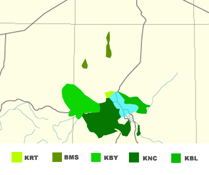
In doing so, the U.S. is wading into the middle of an internationalized civil conflict that has some geographic and historic roots (as they all do). The civil conflict is simply (at the risk of oversimplifying) the lack of proportionate inclusion of a minority population in the political, economic, and social fabric of the states of which they are a part. This, hopefully, sounds familiar. The minority population is the Kanuri ethnolinguistic community, who are predominantly Sunni Muslim (as are other groups in the region), and who are primarily located in Nigeria but also in several neighboring countries, like Cameroon, Niger, Chad.

Kanuri linguistic groups, Lake Chad in blue, via Wikipedia using sources from Ethnologue

Geographically, two themes are relevant. First there is the ever-present legacy of colonialism. No, I’m not going to launch into the expected tirade about North-South relationships (at least not today). For this conflict, one relevant Geography of colonial history is the decline, fall, and subsuming of the Bornu Empire into the British colony in Nigeria, and the French colonies in Niger, Chad, and Cameroon. According to wikipedia, the Bornu empire was comprised of (primarily) of the Kanuri community. This is largely evident in a “visual analysis” of the maps above and below this paragraph.

Bornu Empire ca 1750, via Wikipedia

Having their own polity, the Kanuri people had (until the community’s nadir, just before absorption into the European colonies) control of their political, economic, and social destiny. How far this control (read: freedom) extended to lowest strata of society is an important question. With the empire’s break-up, the Kanuri were divided into several colonies, which eventually became independent states. These independent states, partial democracies (at best), were comprised of several (hundreds, in the case of Nigeria) other ethno-linguistic-sectarian groups – each seeking to maximize political, economic, and social influence.

The other relevant geographic point is, which follows on the earlier one, is the transnational nature of the Kanuri people. As Z Geography has written elsewhere, deconstructing the myth of the homogeneous nation-state (see popular writings on East Asia and Scandinavia for great examples) occupies a significant portion of geographer’s writing. Suffice to say that the transnational nature is, again, evident in the above maps and should be kept in mind while review the below – highlighting the distinct ethno-linguistic identities in Nigeria. Note that the map is from 1979 and is likely to have changed considerably.

Linguistic Groups in Nigeria (1979), via University of Texas

So the Kanuri used to have an empire and are spread across several states, what does that have to do with a violent Islamist insurgency in 2015?

Probably a lot, which brings me to history.

The other principal ethno-linguistic group involved in the Boko Haram violent Islamist insurgency are the Hausa-Fulani. Boko Haram is a loose translation from Hausa, “Fake Forbidden” and signifies that western education should be forbidden. In the place of the partially-free liberal democracy, the group (which was founded in 2002) advocates an Islamic caliphate (a theocracy) based on Islamic laws and jurisprudence.

The BBC article containing this information also mentions the Sokoto Caliphate, a primarily Hausa-Fulani project that also played a direct role in the decline of the Bornu Empire. If wikipedia is to be believe, Sokoto invaded Bornu because of the lapsed nature of their religiosity. The victory was shortlived (around a century) and the Sokoto Caliphate fell to the British by 1903 and elements within the former communities comprising the former caliphate (the Hausa-Fulani and Kanuri) has resisted British (and western) education since.

Boko Haram, however with a few notable exceptions, has primarily involved itself in the Kanuri areas of Nigeria (see map below). This implies, to Z Geography, that the Hausa-Fulani community is not quite on board with the combination of violence, Islamism, and (potentially) Kanuri-specific economic and political grievances.

Probable Boko Haram Attacks (Jan-2010 to Mar-2014), via Business Insider, data from ACLED)

Demographically, why should they be?

Based on the 1952/3 and 1963 censuses, the Hausa-Fulani population (combined) is probably the largest ethno-linguistic group in Nigeria (see reproduced table from a University of Oxford paper, 2005). To put it simply, under a democratic or republican system the largest ethnic groups can simply divide scarce state resources (say, rents from oil production) among themselves. After all, the 3 largest (in 1952) comprised 51% of the population.

Select Ethnic Groups in Nigeria ca. 1952/1953 (from Mustapha, 2005)
Ethnic Group Population Percent
Hausa         5,548,542 17.8%
Igbo         5,483,660 17.6%
Yoruba         5,046,799 16.2%
Fulani         3,040,736 9.8%
Kanuri         1,301,924 4.2%
Tiv            790,450 2.5%
Ibibio            766,764 0.3%
Edo            468,501 1.5%
Nupe            359,260 1.2%
Smaller Groups         8,349,391 29.0%
Nigeria      31,156,027 100%

Indeed, this is the assessment of the Catholic Archdiocese of Abuja (the capital of Nigeria):

Today, political power in Nigeria has become a tribal zero-sum game. The popular assumption is that if the Hausas are in power, they are eating well while the Yorubas and Igbos are losing out. So, the Yorubas and Igbos simply endure and wait until it is their turn. Little wonder, political positions in Nigeria have become fiercely contested. Since Independence, Nigeria has been ruled by a handful of power-wielding oligarchs who, according to John Campbell, “have held power, lost power, and lived to play again.” Those who aspire to the highest office in the land cultivate the friendships of these oligarchs. Whether from the military, politics or business, these oligarchs seek to protect the parochial interests of their subordinates and clients to ensure their continued access to the spoils of office. (via Nigeria’s Guardian News)

But if the Hausa, Yoruba, and Igbo – through sheer demographic weight – are able to sway elections and enjoy the benefits of the state’s patronage, where does that leave smaller, “major” minority groups like the Kanuri? To Z Geography, there are some potential political and economic grievances here.

But these grievances can be a call to action, not necessarily violent action. Leaving aside the nature/nurture debate, it is the contention of some academics that the Nigerian government’s violent crackdown on the group, especially in its early years, was disproportionately violent and served to justify the group’s narrative (see Serrano and Pieri: the Nigerian State’s efforts to counter Boko Haram, pages 194, 199): that the Nigerian government is illegitimate and should be replaced.

Into this complex conflict enters 300 U.S soldiers, marines, sailors, and airmen who will be conducting “intelligence, surveillance, and reconnaissance flights [as well as] enabling operations, border security, and response force capability.” In other words, the United States seeks to address the superficial effects of (at least one) corrupt and rapacious state, by supporting it.

In 20 years, when the Boko Haram group is (finally) stamped out, at the cost of millions of U.S. dollars, and (probably) hundreds of civilians’ lives. Another violent extremist group will take root in Borno state, espousing some ideology promising equitable access to resources and freedom from the yoke of an uncaring government dominated by an enemy ethnic group. This very same government will once again demonstrate that it is not beholden to this minority group, and violently repress it.

***

Organic state update: First, notice also that this violent insurgency in Nigeria has, and has before, cropped up quite far from the capital in Abuja. Second, there may also be an element of “effective capacity” here as well. The Serrano/Pieri chapter, noted above, also discusses the inability of local Nigerian police to effectively deal with local instability due to lack of training and equipment.
Z-Alternative: Russia and the U.S. as Strategic Allies

Let me begin by saying that, as we all know (or could figure out), it takes a lot more than similar geopolitical situations to create a permissive diplomatic and political environment for the creation of an alliance. Similar political and economic systems, histories, ethnic/tribal/sectarian/linguistic political elites, and perception of global threats and interests (and more) play a part in the calculus for a government to commit to the establishment or continuation of a “special relationship”. To borrow the term pundits and publics use to describe the U.S.-UK alliance.

But in this post I will argue that geopolitically, Russia and the U.S. have more common interests than the U.S. and the rest of Europe. While I’ll limit myself to a discussion of the physical geography of this argument, an exploration of the human side is necessary.  The genesis for this post was a great Foreign Affairs article (Why the Ukraine Crisis Is the West’s Fault: The Liberal Delusions That Provoked Putin). One key point in the article is the eastward expansion of the EU and NATO presenting a core threat to Russian security (a very realist, rather than liberal view). It is this point that brought me to today’s post.

Overall, Russia and the United States share a similar geopolitical position. Both are, essentially, protected by their sheer land area. Russia, of course, is in the more tenuous position because of its land borders. Russian strategists and historians are keenly aware of this fact. No less military geniuses than Chinggis Khan (13th century), Napoleon Bounaparte (19th century), and Adolf Hitler (20th century) have invaded. President Putin, and other Russian nationalists and realists, probably view the expansion of NATO and the EU into Ukraine as a prelude to a 21st century invasion.

While the United States has experienced conflict along its two long land borders, these have been resolved since the 19th century and Canada is an ally besides. The main area of concern are the oceans. The water surrounding the U.S. is the guarantor of U.S. security and commerce. Alfred Thayer Mahan understood this in the 19th century, when the British Empire successfully blockaded Napoleon’s continental empire and prevented a French invasion.

The U.S. ability to control the seas has permitted it to consider the entire Western Hemisphere its strategic backyard, much like Russia’s bordering states (the near-abroad). American readers will no doubt recall the Monroe Doctrine of President Monroe (r. 1817-1825), which locked Europe from interfering (and creating new colonies) in North and South America, and President Roosevelt’s Corollary (r. 1901-1909), which saw the U.S. insert itself into bilateral disputes between European and other American states.

There is, as you probably guessed, a realist update to the Monroe Doctrine. The National Interest, an American-conservative foreign policy magazine argued, prophetically, back in 2009 (during President Obama’s historic “reset” with Russia) that:

It would be wise for [President Obama’s] administration to abandon its ill-advised campaign to bring Ukraine and Georgia into NATO, which Moscow justifiably regards as a provocative intrusion into Russia’s security sphere. (The National Interest, A New Monroe Doctrine)

The article acknowledges Russian “violations” of activity in the U.S. strategic backyard.

More worrisome is a hawkish Op-Ed in the Wall Street Journal authored by the American conservative think-tank Foreign Policy Institute (A Monroe Doctrine for NATO). FPI argues that “NATO today should apply something like the Monroe Doctrine to European states that geographic misfortune has placed outside the Alliance but whose sovereignty is essential to a Continent “whole, free and at peace.'” A recipe for just the opposite – a lasting conflict with Russia.

An alternative view, offered by Z Geography is to let the Russia have its strategic backyard, perhaps a neutral Ukraine neither fully in, nor fully out of NATO. Would it be enough to leave Ukraine, and Russia, within the Partnership for Peace? After all the point of that organization is trust-building, which is currently in short supply.

Z Geography argues, over the long-term, this strategic trust-building between the U.S. and Russia could lead to a more meaning partnership and guaranteeing of mutual security. The problem, as it so often is, is Russia’s lack of political and press freedoms. But then again, if we tacitly support President al-Sisi (former general, came to power in a coup) in Egypt, Prime Minister Prayuth (former general, came to power in a coup) in Thailand and various Kings in the Middle East (some of whom are particularly brutal to their people), why not the Russians? Aren’t both governments concerned about a stable Afghanistan? Sunni Islamist terrorism? A rising People’s Republic of China?

After all, aren’t we already pursuing the same strategic interests as Syrian President Asad (who is an Alawite) and Iranian Supreme Leader Khomeini (a Shi’a) in fighting the Islamic State (Sunnis)?

‘Death to Jews’ hamlet row in France

‘Death to Jews’ hamlet row in France http://www.bbc.co.uk/news/world-europe-28764207

Z is trying something new today. Today’s post, geographic naming.

A hamlet in France is known in French as “Death to Jews” or Mort aux Juifs. The name has, again, attracted attention with calls from various organizations to rename the place.

Oddly named places stirring up controversy aren’t new. U.S. states Alaska and Ohio are in a tussle over the name of Mt. McKinley named for an Ohio-born president. Alaska is pressing for the name Denali, from a deity among Alaskan tribes.

And there are other less savory names that have been the subject of controversy. Canada, in 1961, renamed Nigger Creek in British Columbia to Negro Creek.

To Z Geography more effort should be expended in community outreach and development not in, potentially,  bringing litigation against communities. Changing the name of a place doesn’t address prejudice.

What it does do is erase human history. That’s the other lesson, these place names are an important record of things that we should never forget, lest we return to the bad old days of Crusades and purges.

Organic State: New Nexus, encroaching state?

Elsewhere, Z Geography has argued that the lack of the state’s presence has facilitated the rise of (often violent) alternatives to the state. If I haven’t then now I have! The corollary, of course, is that once the state expands into an area then, presumably, the environment is less conducive to a violent insurgency (file all of this under: The Organic State).

This is my hypothesis for the latest Indian state of Telangana, which became the 29th official state in that country’s union (see BBC). As we can see from the two maps below (a little bit of map analysis) the state of Telangana is inheriting a bit of a problem with the naxalite/Maoist insurgency. Back in 2010, then Prime Minister Manmohan Singh called naxalism (named for the West Bengal town that birthed the movement, Naxalbari) the “biggest internal security challenge” facing India. Much of the Telangana (if not all of it) were declared severely Maoist/naxalite-affected by a government study in 2007.

However, the creation of Telangana could be a potential solution for the insurgency, at least in those districts. Like all insurgencies, the naxals thrive in areas inaccessible to state power, in May the Times of India noted a landmine blast in a forest in eastern Maharashtra killed 7 security officers. The other side of the equation, of course, is local support of which Indian tribes provide some support to the movement, not necessarily ideological. Another article from an independent news site suggests two reasons (basically unanticipated policy effects) for tribal support to the Maoists (here).

Telangana could be a solution in that it brings the state, India, closer to the insurgency. It brings a, theoretically, representative government to a smaller number of people in a smaller geographic area. Eventually, the people of Telangana will not have to compete with the local interests of voters in other areas of Andhra Pradesh. This sounds good on paper, the new state government will have to contend with official corruption (always an effective recruitment tool for an insurgency) and a much smaller budget.

On this last point Maharashtra, a state to the west (capital: Mumbai), is reportedly developing infrastructure in naxalite-affected districts to promote tourism (as reported by Times of India). This may be an effective short-term solution, tourism may provide additional employment for locals while also investing them in a wider economy, not to mention that the state security vehicles and tourist buses can use the same roads. Longer-term slaving the local economy to tourism is almost begging for violent disruption (see The Telegraph: Egypt).

Over the next decade, Telangana will slowly come into its own as a state. By then, Z Geography thinks that the naxalite insurgency will disappear from the state or, at least, be driven into obscurity like Spain’s ETA.

India’s New State: Telangana (via BBC)

Maoist Presence within India (2007, via Wikipedia)