Identity and Public Discourse: Reaction to Othello

Z Geography isn’t a blog about the arts, unless it is to opine upon the aesthetics of some map or graphic. The blog does precious little of that. What the blog has tried to do over the years is provide an outlet for my perspective. A forum to air my thought and opinions on things current and strategic. A vain attempt to add to the din that is public discourse in the 21st century.

It is under this framework that Z Geography will offer a critique of the Washington D.C.-based Shakespeare Theatre Company’s adaptation of Othello. I have not read the play, nor have I acted, and I’m sure my experience would have been much improved if not for my fellow theatre patrons who either 1) fell asleep (and snored), 2) crumpled bags, 3) played with straws in plastic cups, 4) talked. But my perspective is as a younger, minority male.

The story itself is simple enough, for those who haven’t read or watched it before. A minority man (written by Shakespeare as a Moor, a North African Muslim), living and working in another society (Venice), tragically falls under the influence of his vengeful friend, Iago.

The obvious parallels to the United States in 2016 are clear. As the BBC points out (indeed the BBC video in the link is one reason I chose to go watch the play late), the play is meant to question ‘Can a Muslim be an American?’ The video features a discussion with the Pakistani-American actor who plays Othello. A quick glance through the Wikipedia page for Othello (reviewed prior) offers imagery often portraying Othello as black. In either case, Muslim-American or Black American, the premise remains the same – how does a majority society often treat its minority communities?

The play is tragedy so the particular outcome is grim.

One thing that I found unfortunate is Othello’s costume changes. In the beginning, i.e. when Othello is at his best, most amicable, he is portrayed in the attire of World War 1 British Army general officer or in shirt sleeves and slacks. Essentially, he is portrayed as a Westerner.

image023

World War 1, British General (The Marshals Baton.com)

Then as Iago’s influence reaches its tragic culmination, Othello changes garb. He abandons Western attire for decidedly Islamic dress.

800px-iraqi_arab_men_in_nishapur-khorasan_28229

Man in thawb (Wikipedia)

To put it plainly, I felt that changing to Islamic dress, and turning away from the West, symbolizes his destruction. In effect, he others himself as the other Venetians have been doing all along (save his wife). Further, the scene in which Othello finally commits to revenge occurs after he kneels for prayer, another symbol of his descent.

To return to the BBC’s original question – “Can a Muslim be American”? It seems that “No, he cannot.” Because everything appears fine if a minority assimilates: take an American wife, and fight American wars. But the xenophobia remains, whether you where Western clothes or not. And when that xenophobia finally succeeds in destroying character, our hapless minority will revert back to his “other”, non-American self and go on a killing spree. After all, he was never American to begin with, right?

If the Shakespeare Theatre Company wanted to thoughtfully answer this question – they would have introduced Othello’s “Muslimness” as an integral part of his identity back in the beginning, not in the end. Because as shown, Othello seems to turn from one identity to another, albeit at the insistence of a sociopath.

Aside from this issue, this play does have another message. Accepting that costume changes as Othello’s change in identity, the play shows how complicit host communities are in radicalizing individuals. For though Iago is the most visible and persistent instigator of Othello’s decline – most of the other characters are prejudiced or biased. (It would have been interested to have made the Cassio character as something of an Affirmative Action apologist, reverse discrimination if you will). Doesn’t Emilia and Desdemona’s father also have some culpability in Othello’s decline?

The parallels here are obvious as Western government are left to wonder why their own citizens join the Islamic State (and if they aren’t, they should be). While there is an undeniable element of personal responsibility – nothing happens in a vacuum. Minority communities and, more importantly, majority societies need to take a critical look at their rhetoric and values.

Perspective: The Pale Blue Dot

Today is Veteran’s Day in the United States. It used to be called Armistice Day and that name is still used by other countries who were party to World War I. While not your normal Z Geography post, per se, I will offer some geographic perspective for your consideration. While we rightfully honor hundreds of thousands of veterans and their families – who often died for our or others’ ability to choose their government or because of our honored obligations – we should also consider our own actions and those of our leaders that ultimately support bringing death, despair, and destruction to others. For a leader’s policies can result in torture, oppression, lost liberty, and worse – My Lai, Samar. I contend that no single nation, state, or religion is without this stain – so, this is a call to action for everyone and anyone.

Is Z Geography calling for a world without war? Sure, that would be nice but nearly impossible. Populist demagogues probably will continue to find ways to power and they will continue to find a willingly and supportive audience. Even worse, democratic and autocratic regimes probably will continue to alternate between domestic oppression and external conflict to advance their narrow self-interests. War, like it or not, is a part of a politician’s toolbox. It would be nice for everyone to remove that tool simultaneously.

Until that happens, the common citizen can do little more than hold their own elected (and unelected representatives) accountable for their policies. Especially the ones that bring unnecessary death, despair, and destruction. And consider, perhaps, holding these same individuals accountable for lack of policies that stop unnecessary death, despair, and destruction – Rwanda, Cambodia’s Killing Fields.

A final, geopolitical point. Such an activity by the citizen, probably would force leadership from abandoning the politically-expedient fiction that their country does not attempt to influence the internal affairs of some other state. After all, Russia is in Syria, and the Presidents of the two Chinas met (for the first time in over a half-century), barely two months before a presidential election in Taiwan.

After all, we’re all housemates in the only house in the neighborhood.

Inspiration for this post is wholly drawn from the BBC, which released a film and an accompanying article to mark the astronomer Carl Sagan’s birthday on November 9, 1934 (he passed away December 20, 1996). The eponymous pale blue dot can be found in the Voyager 1 satellite image below. Look in the far right, yellow sunbeam just below the midpoint of the image. Carl Sagan’s remarks on the subject are available on the BBC article and at the Library of Congress. A section is reproduced below.

The Pale Blue Dot (Voyager 1, 1990, NASA, via BBC)

The Earth is a very small stage in a vast cosmic arena. Think of the rivers of blood spilled by all those generals and emperors so that in glory and triumph they could become the momentary masters of a fraction of a dot. Think of the endless cruelties visited by the inhabitants of one corner of this pixel on the scarcely distinguishable inhabitants of some other corner. How frequent their misunderstandings, how eager they are to kill one another, how fervent their hatreds. Our posturings, our imagined self-importance, the delusion that we have some privileged position in the universe, are challenged by this point of pale light. Our planet is a lonely speck in the great enveloping cosmic dark. In our obscurity – in all this vastness – there is no hint that help will come from elsewhere to save us from ourselves. — Carl Sagan, 1990

The price of “somewhere”: Gentrification and Equality

The title, as long time readers have already figured out, plays on my favorite geography book – James H. Kunstler’s The Geography of Nowhere: The Rise and Decline of America’s Man-Made Landscape.The book, written in the mid-/late-1990s, is an excellent perspective on the history of the United States’ built landscape, specifically the typical American suburb (of which Z Geography is intimately familiar). The book reads as a eulogy for the “classic” American small-towns of the northeast. The “Main Street” that modern politicians are so fond of recalling. These towns and villages were small, reasonably compact, intimate, and green. In other words, the complete antithesis of the modern suburb.

In this post, we’ll discuss how these “Nowheres” are in transition to becoming “Somewheres” in both cities and suburbs. In highlighting the disparate, but legitimate, interests associated with development as well as its pitfalls, I’m hoping to draw your attention to the importance of these political choices. Beyond politics, there is also room for decency.

As any urban resident will tell you, things are changing. White Americans are returning, following the well-discussed “White Flight” of the 1950s and 1960s, when the racial group left cities for safer, cleaner, newer suburbs. The process of returning and the development associated with it has been coined gentrification. Gentrification involves an increase in home values and better delivery of public goods (e.g. education, transportation, security) – city managers like the increased tax revenue. Young, white families like being in a city while enjoying more effective utilities. Of course, there are already residents living in these cities – black home owners and renters, with decidedly less income, who are eventually “encouraged” out by developers or high property values.

These disparate outcomes increased development while original residents are pushed out have been discussed in some media. Recently, the Washington Post described how large, predominantly black, churches in Washington, DC are attempting to prevent the creation of bike lanes on the streets near the church. As the Post observes:

  • “the packed meeting…highlighted a tension in the rapidly changing District [of Columbia] between longtime, black residents and new, largely white residents.”
  • “These conflicts stem from the change in D.C.’s neighborhoods. Many of D.C.’s churches were built at a time when their neighborhoods, such as Shaw, weren’t as teeming with condos and restaurants,  and parking wasn’t as big of an issue. Additionally, many longtime churchgoers have left the city for the suburbs and now commute to their old churches by car.”

The issue relates to a proposal to establish bike lanes on streets near the church, thus removing parking spaces. While not summarized as such the “conflict” (because that is what it is) is between two distinct social groups (blacks, whites) on how best to use (in this case transportation) a finite, terrestrial resource (land). Again the Post:

  • “This ain’t London, this ain’t Europe. The United States is built on the automobile and we need to respect that,” said Michael Green, a deacon at New Bethel Baptist Church.
  • “Washington Area Bicycle Association, a group that advocates for cycling in the city, argues that bike lanes wouldn’t prevent anyone from going to church.  There are other modes of transportation available to churchgoers, and bike lanes are necessary for the safety of the city’s increasing number of cyclists.”

The conflict, obviously, is ultimately a political question and as the Advisory Neighborhood Commission member notes in the article not everyone is going to be happy with the outcome. The Washington Post article presents both sides of the dispute as legitimate stakeholders with competing interests. Often, it is too easy to characterize (or spin, if you like) these conflicts into easily identifiable “right” and “wrong” positions under a completely different narrative, one for each stakeholder.

Gentrification is not only happening in America’s cities, it is also happening in some of the suburbs as well. Considering that many of suburbs are still more affluent (and house predominantly whites) than the cities they surround, what I’m really referring to is the development or transformation of these communities.

Politico describes the ongoing transformation in a suburb outside Chicago, Evanston, Illinois, which trying to “kill the car” as the title notes. The article is a 5-page look at a new-old concept: transit-oriented development (TOD). New because, Americans (sometime after Europeans) “rediscovered” it. Old because we employed this concept with railroads and streetcars. Evanston’s planning (since 1986) involves mixed-use development (i.e. residential and commercial) close to one another near a transit node (hence transit-oriented development). The theory is to promote walkability within insulated communities – walk from your apartment to the grocery store, bakery, or school. But, if your job is in Chicago, then there is a light rail just down the street. The net effect, of course, is to make cars useless.

Unfortunately, Politico gives decidedly short thrift to the problems of development and gentrification (you have to dig to page 5). According to the article, critics of TOD refer to it as “transit oriented displacement.” There is only a general mention of “affordable housing” as a potential explanation to how TOD, with its rising property values and prices, generates “diverse neighborhoods—diverse in population, retail, entertainment and housing”.

At the moment, according to the 2010 Census, Evanston was more racially and ethnically diverse compared to the rest of Illinois (66% White, 72% White respectively). However, the city is also markedly more affluent based on average income and with median home values of over $350,000 compared to $182,000. There is already a bar to live in this transforming suburb where a car is not as necessary. The unintended consequence, without guaranteed affordable housing, is to permit an elite core of residents the luxury of short commutes, walkability, and liveability, while a much larger group of workers must commute in – probably with cars – because they can’t afford it.

There are no easy solutions to these political problems. How do we as a local electorate balance the desires of newcomers with the desires of long-time residents? Many would argue that these questions should be decided at the ballot box – but that is also a tyranny of the majority. A time may not be far off when your majority becomes a minority – what then will we have built? What precedent would you have set?

Geography Basics: U.S.-west Africa-Boko Haram

The German philosopher Immanuel Kant proposed that human knowledge could be organized in three ways. First, one could study the object specifically, toxicology, chemistry, geology, botany, and so on. Second, one could study an object based on time, history. Third, one could study an object based on its spatial relationships, Geography.

In the news this week was the revelation that the United States will be expending geopolitical power (i.e. deploying military personnel, via Voice of America) in checking the growth of violent Islamist movements in western Sub-Saharan Africa, to include Boko Haram.

(U.S. troops being deployed to northern Cameroon to assist fighting violent Islamists [Lake Chad in blue], via Voice of America)

In doing so, the U.S. is wading into the middle of an internationalized civil conflict that has some geographic and historic roots (as they all do). The civil conflict is simply (at the risk of oversimplifying) the lack of proportionate inclusion of a minority population in the political, economic, and social fabric of the states of which they are a part. This, hopefully, sounds familiar. The minority population is the Kanuri ethnolinguistic community, who are predominantly Sunni Muslim (as are other groups in the region), and who are primarily located in Nigeria but also in several neighboring countries, like Cameroon, Niger, Chad.

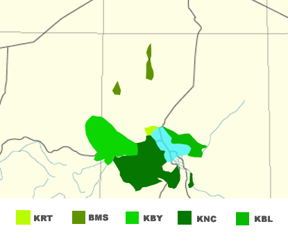
Kanuri linguistic groups, Lake Chad in blue, via Wikipedia using sources from Ethnologue

Geographically, two themes are relevant. First there is the ever-present legacy of colonialism. No, I’m not going to launch into the expected tirade about North-South relationships (at least not today). For this conflict, one relevant Geography of colonial history is the decline, fall, and subsuming of the Bornu Empire into the British colony in Nigeria, and the French colonies in Niger, Chad, and Cameroon. According to wikipedia, the Bornu empire was comprised of (primarily) of the Kanuri community. This is largely evident in a “visual analysis” of the maps above and below this paragraph.

Bornu Empire ca 1750, via Wikipedia

Having their own polity, the Kanuri people had (until the community’s nadir, just before absorption into the European colonies) control of their political, economic, and social destiny. How far this control (read: freedom) extended to lowest strata of society is an important question. With the empire’s break-up, the Kanuri were divided into several colonies, which eventually became independent states. These independent states, partial democracies (at best), were comprised of several (hundreds, in the case of Nigeria) other ethno-linguistic-sectarian groups – each seeking to maximize political, economic, and social influence.

The other relevant geographic point is, which follows on the earlier one, is the transnational nature of the Kanuri people. As Z Geography has written elsewhere, deconstructing the myth of the homogeneous nation-state (see popular writings on East Asia and Scandinavia for great examples) occupies a significant portion of geographer’s writing. Suffice to say that the transnational nature is, again, evident in the above maps and should be kept in mind while review the below – highlighting the distinct ethno-linguistic identities in Nigeria. Note that the map is from 1979 and is likely to have changed considerably.

Linguistic Groups in Nigeria (1979), via University of Texas

So the Kanuri used to have an empire and are spread across several states, what does that have to do with a violent Islamist insurgency in 2015?

Probably a lot, which brings me to history.

The other principal ethno-linguistic group involved in the Boko Haram violent Islamist insurgency are the Hausa-Fulani. Boko Haram is a loose translation from Hausa, “Fake Forbidden” and signifies that western education should be forbidden. In the place of the partially-free liberal democracy, the group (which was founded in 2002) advocates an Islamic caliphate (a theocracy) based on Islamic laws and jurisprudence.

The BBC article containing this information also mentions the Sokoto Caliphate, a primarily Hausa-Fulani project that also played a direct role in the decline of the Bornu Empire. If wikipedia is to be believe, Sokoto invaded Bornu because of the lapsed nature of their religiosity. The victory was shortlived (around a century) and the Sokoto Caliphate fell to the British by 1903 and elements within the former communities comprising the former caliphate (the Hausa-Fulani and Kanuri) has resisted British (and western) education since.

Boko Haram, however with a few notable exceptions, has primarily involved itself in the Kanuri areas of Nigeria (see map below). This implies, to Z Geography, that the Hausa-Fulani community is not quite on board with the combination of violence, Islamism, and (potentially) Kanuri-specific economic and political grievances.

Probable Boko Haram Attacks (Jan-2010 to Mar-2014), via Business Insider, data from ACLED)

Demographically, why should they be?

Based on the 1952/3 and 1963 censuses, the Hausa-Fulani population (combined) is probably the largest ethno-linguistic group in Nigeria (see reproduced table from a University of Oxford paper, 2005). To put it simply, under a democratic or republican system the largest ethnic groups can simply divide scarce state resources (say, rents from oil production) among themselves. After all, the 3 largest (in 1952) comprised 51% of the population.

Select Ethnic Groups in Nigeria ca. 1952/1953 (from Mustapha, 2005)
Ethnic Group Population Percent
Hausa         5,548,542 17.8%
Igbo         5,483,660 17.6%
Yoruba         5,046,799 16.2%
Fulani         3,040,736 9.8%
Kanuri         1,301,924 4.2%
Tiv            790,450 2.5%
Ibibio            766,764 0.3%
Edo            468,501 1.5%
Nupe            359,260 1.2%
Smaller Groups         8,349,391 29.0%
Nigeria      31,156,027 100%

Indeed, this is the assessment of the Catholic Archdiocese of Abuja (the capital of Nigeria):

Today, political power in Nigeria has become a tribal zero-sum game. The popular assumption is that if the Hausas are in power, they are eating well while the Yorubas and Igbos are losing out. So, the Yorubas and Igbos simply endure and wait until it is their turn. Little wonder, political positions in Nigeria have become fiercely contested. Since Independence, Nigeria has been ruled by a handful of power-wielding oligarchs who, according to John Campbell, “have held power, lost power, and lived to play again.” Those who aspire to the highest office in the land cultivate the friendships of these oligarchs. Whether from the military, politics or business, these oligarchs seek to protect the parochial interests of their subordinates and clients to ensure their continued access to the spoils of office. (via Nigeria’s Guardian News)

But if the Hausa, Yoruba, and Igbo – through sheer demographic weight – are able to sway elections and enjoy the benefits of the state’s patronage, where does that leave smaller, “major” minority groups like the Kanuri? To Z Geography, there are some potential political and economic grievances here.

But these grievances can be a call to action, not necessarily violent action. Leaving aside the nature/nurture debate, it is the contention of some academics that the Nigerian government’s violent crackdown on the group, especially in its early years, was disproportionately violent and served to justify the group’s narrative (see Serrano and Pieri: the Nigerian State’s efforts to counter Boko Haram, pages 194, 199): that the Nigerian government is illegitimate and should be replaced.

Into this complex conflict enters 300 U.S soldiers, marines, sailors, and airmen who will be conducting “intelligence, surveillance, and reconnaissance flights [as well as] enabling operations, border security, and response force capability.” In other words, the United States seeks to address the superficial effects of (at least one) corrupt and rapacious state, by supporting it.

In 20 years, when the Boko Haram group is (finally) stamped out, at the cost of millions of U.S. dollars, and (probably) hundreds of civilians’ lives. Another violent extremist group will take root in Borno state, espousing some ideology promising equitable access to resources and freedom from the yoke of an uncaring government dominated by an enemy ethnic group. This very same government will once again demonstrate that it is not beholden to this minority group, and violently repress it.

***

Organic state update: First, notice also that this violent insurgency in Nigeria has, and has before, cropped up quite far from the capital in Abuja. Second, there may also be an element of “effective capacity” here as well. The Serrano/Pieri chapter, noted above, also discusses the inability of local Nigerian police to effectively deal with local instability due to lack of training and equipment.